MOUNTAIN SYSTEM OF HIMACHAL PRADESH
Himachal literally means 'land of snowy mountains' the very name Himachal is conglomeration of 'Hima+Achala'. The 'Hima' here stands for snow, purity, whiteness. Snow is pure, untamed and extremely cool. All these endow it with the quality of perfect peace (Prasanthi). And the "Achala" stands for something steady, steadfast, faithful, unshakable and mountain like. Himachal Pradesh is a small world in itself, accessible through the plains of Punjab or Shivalik hills or through the hills of Shimia, via, beautiful "meandering valleys, covered with pine and typical temperate mountain flora.
Himachal Pradesh is bounded between 30°22" to 33°12" North latitude and 75°47" to 79°4" East longitude. The Himalayan mountain chain stretches in an arcuate shape to a length of about 2400 kms. from the 'Naga Parbat' peak in the North West to the 'Namche Barwa' peak in the North East. Its width varies from 150 to 300 kms. Himachal takes its name from the Himalayas. In the North, it is bounded by Kashmir, the valley of Saffron; in the South-East by The whole territory of Himachal Pradesh is mountainous with altitude varying from 350 to 4500 meters above the mean sea level. It lies entirely in the 'Western Himalaya'. The state of Himachal Pradesh is a full fledged state of Indian Union. The total area of the state is 55,673 sq. km.
Along the boundary of the state with the Indo-Gangetic plain (Punjab and Haryana) there emerge low rolling hills with razor sharp ridges. Towards North there are higher mountain ranges and deep valleys. The physiography of the state is a complex mosaic of hills, valleys and snow-clad peaks. The white snow clad mountain ranges towering over the plains of North India are most prominent physical feature of the state. These are the Dhauladhar, Pir Panjal, the great Himalayan and trans-Himalayan ranges which are visible from a distance. The steep mountain slopes are covered with coniferous and broad-leaved forests, meadows, pastures and terraces often clinging precariously to the mountain sides. The valleys lying amidst these mountain ranges contain gurgling streams, torrents, terraced fields and fairy tale villages. Topographically, the territory of Himachal Pradesh can be divided into following zone:
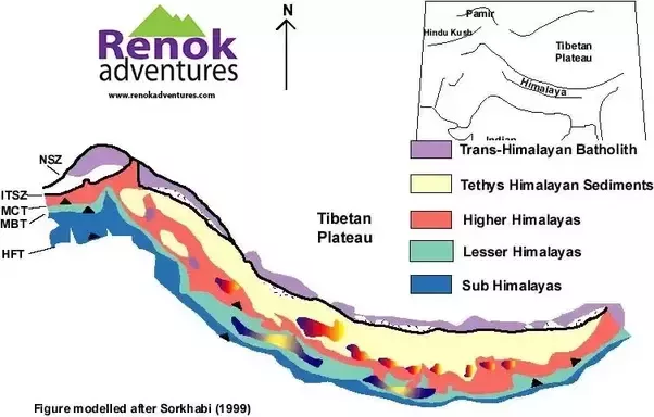
The Mountain System
The Lower Hills or Shivalik :
This area is also known as the outer Himalayas or the sub-Himalayan Zone. These are the outer most hills of the State that stretch along its Southern boundary from East to West with average elevation of 600 meters and steep Southern slopes that gently dip into the longitudinal Valleys known as the 'Duns'. Comprising the lower parts of district Kangra, Hamirpur, Una, Bilaspur and Lower parts of Mandi, Solan and Sirmaur are known as Shivalik hills. The annual rainfall in this zone varies from 1500 mm to 1800 mm. The altitude of this zone is from 350 meters or 1050 feet to 1500 meters or 4500 feet above sea level. This area is suitable for the cultivation of maize, wheat, ginger, sugarcane, paddy, table potatoes and citrus fruits. To the ancient, Shivalik hills were known as 'Manak Parbat'.
The Shivaliks consists predominantly of tertiary formations extending from North-West to South-East. They comprise of great thickness of detrital rocks, clays and conglomerates. The Shivalik chain is widest in the Beas Valley. The Shivalik belt of rocks are considered to be the youngest in age. Shivaliks have been highly deforested and eroded resulting in the formation of 'Chos'. These ranges are mainly of scattered, stony and sandy hillocks. The greatest height of these ranges above the Gangetic plain is not more than 915 meters. Densely forested Shivaliks are the home of wild animals like tiger, leopard , bear, etc. Scrub forests cover the South facing slopes of the Shivaliks, sal forests are on the Northern slopes in the East, and miscellaneous broad leaved forests are found in the West. This shows that the North facing slopes are moistureous.
The Inner Himalya or Mid- Mountain :
This portion of the Himalayas also known as Lower Himalayas or the Central Zone. It occupies the central part of Himachal Pradesh. Most of this zone is composed of granite and other crystalline rocks of unfossiliferous sediments. Here severe tectonics have affected the crystalline rocks and led to the formation of the crystalline klippen as in the Shimla area. In the South the rise is more abrupt in the Shimla hills. In this zone falls areas like, upper areas or the tehsils of Pachhad and Renuka in Sirmaur district, Chachiot and Karsog tehsils of Mandi district; upper parts of Kangra and Palampur tehsil of Kangra district; upper Shimla hills, and upper parts of Church tehsil of Chamba district. The altitude of this zone varies from 1500 meters or 4500 feet to 4500 meters or 13,500 feet above sea level. This zone is useful for seed potatoes, temperate fruits, stone fruits and soft fruits. Two famous ranges of Lesser Himalaya are: the Pir Panjal (in Chamba district) and Dhauladhar (Kangra district). The main species in this range includes oaks, chir, pine, deodar, blue pine, fir, spruce, hemlock,. rhododendron, chestnut, walnut, sub-alpine and alpine pastures.
Dhauladhar Range :
The Dhauladhar range looks in supreme majesty over the Kangra Valley and presents a fascinating panorama. It is also known as'The White Range' and forms the most striking feature. It breaks off from the Great Himalayan range near Badrinath, and intercepted by the Satluj at Rampur Bushahr, by Beas at Larji and by Ravi at South-West of Chamba. Kangra Valley is a longitudinal trough at the foot of the Dhauladhar range. The mean elevation of this range is about 4550 meters,while above the Kangra Valley the rise of Dhauladhar is just about 3600 meters only. Dhauladhar in Chamba district forms Southern boundary of the district and separates it from Kangra district. This range in Chamba district forms a mountain barrier with high peaks. Hathi Dhar is another range quite conspicuous in this region. It is a lower hill range which runs parallel to Dhauladhar in its South. A narrow fertile tract is formed between Dhauladhar and Hathi Dhar in Chamba district.
Dhauladhar range in Kinnaur district constitutes the South-Western part of the district and forms a longitudinal belt along the boundary line between Kinnaur and Shimla, and Uttaranchal in its South. Dhauladhar in its Western half runs parallel to the Satluj river and its Eastern half runs parallel to the Baspa river which is one of the main tributaries of Satluj river. This range in Kinnaur district gives origin to some streams and rivulets like Zupkia Gad and Mukti Gad which join Baspa river. Dhauladhar extends in North and North-Eastern direction of Mandi district and runs in continuation of Dhauladhar of Kangra district in North-West to South-East direction passing through North-Eastern Jogindernagar tehsil and Mandi tehsil. Generally Dhauladhar range is considered a Granite body. Dhauladhar meaning, "Grayish white" is the outer most portion of Lesser Himalayan range.
Pir Panjal Range :
The Lesser Himalayas is marked by a gradual elevation towards Pir Panjal. The Northern flank of the Dhauladhar range impinges against the Southern flank of the Pir Panjal range (average elevation 4600 meters) at the mountain knot of Bara Benghal. The Pir Panjal, the largest and most impressive of the Lesser Himalayan ranges bifurcates from the Great Himalayan Range near the bank of Satluj, forming the water parting, between Chenab on one side, Beas and Ravi on the other, bending towards the Dhauladhar range near the source of the Ravi. Pir Panjal range in Chamba district forms a longitudinal mountainous tract streching from North-West to South-East direction between Ravi basin in the South and Chandra Valley in the North. It is a long mountain range and extends beyond Chamba district to Northern Kullu district and adjoining area of Lahaul-Spiti and Kangra districts. In Kullu district Pir Panjal lies in its extreme Northern and North-Western parts. There are steep slopes in this region. Beas river rises from the Beas Kund (3540 meters) near Rohtang Jot in the Pir Panjal and flows towards South.
Massorie Ridge :
This imposing ridge runs Westward from Mussoorie in Uttaranchal and crosses to Himachal Pradesh in the North of Sataun, where it is cut through by the Yamuna river. Thereafter it runs to the North of the Giri river before culminating in the Churdhar massif. It is the highest peak in the lower Himalayas between Shimla and Sirmaur districts.
Shimla Ridge
The Shimla ridge marks the watershed of the rivers Ganga and Indus. In other words the slopes of the Western side drain in to the Arabian Sea, whereas the water on the Eastern slopes finds its way to the Bay of Bengal.
The Greater Himalya Or Alpine Zone :
This zone comprises Kinnaur district, Pangi-tehsil of Chamba district and some areas of Lahaul-Spiti. The altitude of this zone varies from 4,500 meters and above mean sea level. The rainfall is scanty in this zone. Climate is temperate in Summer and semi-arctic in winter. Climate and soil is best suited to the cultivation of dry fruits. The range is also known as the Northern Zone. The Great Himalayan range having an elevation between 4500 meters to 6000 meters of a towering snow clad ridge that runs along the North-Eastern border of the State and then turns Southwards, separating the Trans-Himalayan Zones of Pooh, Lahaul and Spiti from the rest of the country. This range is cut across by the defile of the Satluj. Also, this range separates the drainage of the Spiti river from that of the Beas. Some of the famous Passes like Baralacha and Rohtang are across this range. With steep slopes in Kullu this range rises abruptly over a broad open Valley, thus making a contrasting sharp increase in elevation. The Southern slopes are ladden with deodar, fir, blue pine, spruce, morn and kharsu oaks, hemlock, rhododendron, sub alpine betula and alpine meadows. The northern slopes are largely devoid of vegetation except very few occasional tufts of grasses that appear at lower elevation in summer. This Alpine and Arid Zone which consists of Lahaul, Spiti, Kinnaur (Pooh) and Pangi areas is mainly a tribal belt. The Valleys secluded and protected by the deep jungles and the high mountains evolved a distinct civilization that has produced and preserved some of the most interesting remnants of great historical significance.
Trans Himalyas :
This is a zone of an average elevation of over 3000 meters. This physiographic unit comprises of areas located to the North of the Main or Great Himalayan range. Here, conditions resemble to almost those found in Tibet. As the moisture laden South-West monsoon clouds fail to cross the Main Himalayan range hence rainfall is very scanty. This zone forms mainly Lahaul-Spiti district and Pooh tehsil of Kinnaur district.
Zanskar :
The Zanskar range stretching South Eastwards frorn Ladakh is the most prominent mountain range of the trans-Himalayan part of Himachal Pradesh. It separates Spiti and Kinnaur from Tibet. It has numerous peaks having an elevation of around 6500 meters. This range is cut across by the Satluj through its Shipki defile. On the whole the soils are fresh and soft and any depth interm whatsoever occurs is in the Valleys or on gently inclined hill slopes. The trans-Himalayan zone is largely devoid of forest vegetation. It is only in summer that occasional tufts of grasses and natural flowers appear on the mountain slopes.
Tethys Himalyan Zone :
It covers the Spiti Valley. Its richness in fossil wealth almost continuous, well exposed sections have made Spiti a world famous region yet remains unexplored so far by the geologists due to inaccessibility on account of topographical and geographical factors.
Himalayas have always been important not only in influencing Indian climate but in determining the geopolitical scenario of the country. This belt has become fragile for seismic activities, landslides and soil erosion due to deforestation. These processes coupled with political instability are largely responsible for slow rate of urbanization in this region. The Shivalik foot-hills have experienced high rate of urbanization right from Pir Panjal in the North-West to the Arakan belt in the North-East mainly due to tourist resorts. Next to the Shivalik foot-hills are the Valleys of Kashmir, Kullu, Dun and Duar plains in the South of Bhutan, Kohima and Manipur Valleys known for orchard farming, tea gardening and rice cultivation.
Also, with the improvement in Sino-Indian relations, silk and salt routes leading to China have widenea the scope of urbanization and trading activities in these areas. Due to cantonment and military settlements with the development of the infrastructural facilities these areas are transforming into the centres of tourist attraction. So the trans-Himalayan zones which were extremely backward at the time of independence have now developed into an important centres of tourist attractions, such as Leh, Gangtok and Phuntsholing. The trade agreements signed between India and China duringl G96-2006 have definitely shown remarkable progress in the zone.