Transport network in Assam can be categorized into four categories:
1. Road
2. Railways
3. Waterways
4. Airway
Road Network:
- Assam is entrance to the entire northeastern part of India. It is connected to rest of India by vary narrow stretch called chicken neck or Jalpaiguri corridor. It has strategic importance for India since it is only point of contact to the northeastern part of India.
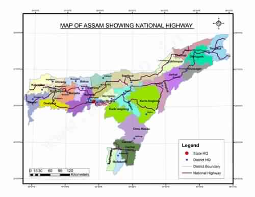
- Road Network can further be categories into National Highway, State Highway, District Roads, and other roads.
National Highway network in Assam is as follows:
- 1. 31 From W.B. Border-Gouripur-North Salmara-Bijni- Charaliamingaon Junction with NH No.37 322
- 2. 31B North Salmaria-Abhayapuri-Junction with NH No37 near Jogighopa 19
- 3. 31C From W.B. Border-Kochugaon-SidliJu. With NH-31 near Bijni 93
- 4. 36 Nagaon-Dabaka-Amlakhi-Nagaland Border 167
- 5. 37 Dispur-Nowgong-Numaligarh-Jorhat-Jhanzi-Dibrugarh-Tinsukia- Makum-Saikhoghat 680
- 6. 37A Kuwari Tal – Junction with NH.No.52 near Tezpur 23
- 7. 38 Makum-Ledo-Likhapani 54
- 8. 39 Numaligarh-Naojan-Bokajan-upto Nagaland Border 115
- 9. 44 From Meghalaya Border- Badarpur-Karimgant-Patharkandi- upto Tripura Border 111
- 10. 51 Paikan-upto Meghalaya Border 22
- 11. 52 Baihata-Charali-Mangaldai-Dhekiajuli-Tezpur-Gohpur-BanderDewa- North Lakhimpur-Dhemaji- Kulajan-Arunachal Border- Junction with NH No.37 near Saikhoaghat 540
- 12. 52A Gohpur-A.P. Border-BanderDewa 15
- 13. 52B Kulajan-Dibrugarh 31
- 14. 53 Junction with NH-44 near Badarpur-Silchar-Lakhipur- upto Manipur Border. 100
- 15. 54 Dabaka-Lumding-Langting-Haplong- Silchar-Dwarbandupto Mizoram Border 335
- 16. 61 Jhanzi-Amguri-Nagaland border 20
- 17. 62 Dudhnai-Damara- upto Meghalaya Border 5
- 18. 151 Karimganj-Bangaladesh Border 14
- 19. 152 Patacharkuchi-Hajua-Bhutan Border 40
- 20. 153 Ledo-Lekhapani-Arunachal Pradesh Border 20
- 21. 154 Dhaleshwar (Badarpur)-Bhairabhi -Mizoram Border 110
State Highway in Assam:
- Assam State Highway 1 ->Dhodar Ali State Highway
- This highway covers following district:-Golaghat, Jorhat, Sivasagar, Dibrugarh
- Total length is 450.10 km.
- Assam State Highway 2->Bongaigaon North– Salmara Abhayapuri Langla Jania Barpeta Mukalmua Kalitakuchi Amingaon North–Guwahati
- This highway covers following district:-Bongaigaon, Barpeta, Nalbari, Kamrup
- Total length is 161.0 km.
Railways in Assam:-
- The railway route length in Assam is approximately 2400 km long. Assam is well linked through Rail Services to major Indian cities.
- Assam is the largest and the most conveniently accessible state in the north east states. History of Railways dates to 1881 when Assam Railway & Trading Company set up the meter gauge track.
- Originally, this track constructed for tea and coal transportation.
- In January 1958, two railway networks were formed, the North Eastern Railway and the Northeast Frontier Railway.
- The Northeast Frontier Railway abbreviated as N.F. Railway, is one of the 17 railway zones in India. Headquartered in Maligaon, Guwahati in the state of Assam, it is responsible for rail operations in the entire Northeast.
- The railway headquarter of the state is in the Guwahati and has direct train services from major cities in India.
- The Rajdhani Express from New Delhi and Saraighat Express from Howrah in Kolkata are the fastest trains to Assam. Railways are the easiest and cheapest way to travel to and within Assam.
- The Railways Ministry has carried out various developmental actions in the State’s Railway including extension of rail line to connect with the other Northeast states of Meghalaya, Mizoram and Arunachal Pradesh through Assam.
- A few new passenger trains were introduced to connect various places within the state during the last few years.
Waterways:
- Due to availability of perennial source of water in Brahmaputra river, waterways has developed significantly in the state of Assam.
National waterways number 2 extends from Sadiya to Dhubri in Assam. It has been declared NW in year 1988.
- Total length of this waterway is 891 km. This waterway is being used by vessels of Govt. of Assam, CIWTC, Border security Forces, Tourism vessel, other private operators.
- NW 6: Barak river from Bhanga to Lakhipur
Airways:
- Assam state of India is well connected with the rest of the country through Air Transport. The operational civil airports in the state are located at
- 1. Guwahati,
- 2. Tezpur,
- 3. Jorhat,
- 4. Dibrugarh,
- 5. Lakhimpur
- 6. Sichar
Apart from these, there are several private airstrips operated by tea gardens in Assam. LokapriyaGopinathBordoloi International Airport at Guwahati is the only International airport. It is also the only International Airport in the North-East India.
The Guwahati airport is the busiest of all airports in Assam. After Guwahati, Dibrugarh and Jorhat are the 2nd and 3rd major airports in Assam. All major domestic airlines including private commercial airlines such as Air India, Jet Airways, JetLite, SpiceJet, Indigo and GoAir operates regular ??ights to and from Assam.