Indira Gandhi Canal - life line of Rajasthan :
The Indira Gandhi Canal the longest canal of India . It starts from the Harike Barrage at Harike, a few kilometers below the confluence of the Satluj and Beas rivers in the Indian state of Punjab and terminates in irrigation facilities in the Thar Desert in the north west of Rajasthan state. Previously known as the Rajasthan Canal, it was renamed the Indira Gandhi Canal on 2 November 1984 following the assassination of Prime Minister Indira Gandhi.
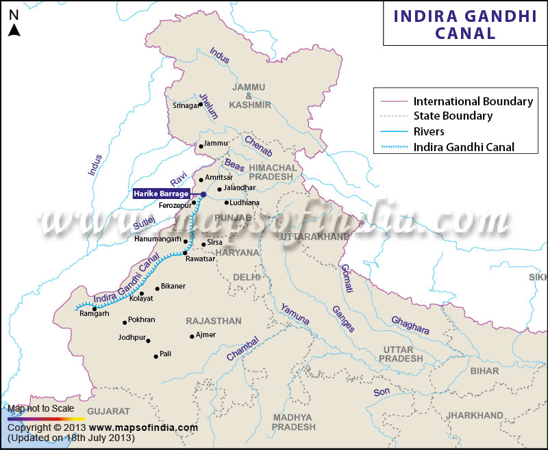 The canal consists of the Rajasthan feeder canal with the first 167 kilometres (104 mi) in Punjab and Haryana state and a further 37 kilometres (23 mi) in Rajasthan followed by the 445 kilometres (277 mi) of the Rajasthan main canal, which is entirely within Rajasthan. The canal enters Haryana from Punjab near Lohgarh village then runs through the western part of the Sirsa districtbefore entering Rajasthan near Kharakhera village in the Tibbi tehsil of the Hanumangarh district. The canal traverses seven districts of Rajasthan: Barmer, Bikaner, Churu, Hanumangarh, Jaisalmer, Jodhpur, and Sriganganagar.
Design and Construction :
The idea of bringing the waters from the Himalayan Rivers flowing through Punjab and into Pakistan was conceived by an hydraulic engineer, Kanwar Sain in the late 1940s who proposed that 2,000,000 ha (20,000 km2) of desert land in Bikaner and the northwest corner of Jaisalmercould be brought under irrigation from the stored waters of Punjab rivers. In 1960, Indus Water Treaty was signed between India and Pakistan which gave India the right to use waters of three rivers –the Satluj, Beas and Ravi. The proposed Rajasthan Canal envisaged use of 7.6 million acre feet of water.
The initial plan was to build the canal in two stages, Stage I consisting of 204 km (127 mi) feeder canal from Harike barrage in Punjab. Stage I also included constructing distributary canal system of about 2,950 km (1,830 mi) in length. The stage II involved construction of 256 km (159 mi) long main canal and distributary canal network of 3,600 km (2,200 mi). It was planned that the main canal will be 140 ft (43 m) wide at the top and 116 ft (35 m) wide at the bottom with water depth of 21 ft (6.4 m). The canal was scheduled to be completed by 1971.
The stage I could not be completed in time due to severe financial constraints, neglect and corruption. In 1970 the plan was revised and it was decided that the entire canal will be lined with concrete tiles. Five more lift schemes were added. Flow command of stage II was increased by 100,000 ha (1,000 km2). With increased requirements, the total length of main, feeder and distribution canals was about 9,245 km (5,745 mi). The stage I was completed in 1983 around 20 years behind the completion schedule.
Green Revolution in Rajasthan by indira gandhi canal:
After the construction of the Indira Gandhi Canal, irrigation facilities were available over an area of 6,770 km2 (1,670,000 acres) in Jaisalmer district and 37 km2 (9,100 acres) in Barmer district. Irrigation had already been provided in an area of 3,670 km2 (910,000 acres) in Jaisalmer district. The canal has transformed the barren deserts of this district into rich and lush fields.[citation needed] Crops of mustard, cotton, and wheat now flourish in this semi-arid north-western region replacing the sand there previously.
Benefits :
1. Indira Gandhi Canal provides irrigation water to an arid area in Rajasthan starting Ganganagar district to Jalselmer along the Indo-Pakistan border. It has helped turn a significant part of the Thar desert to an agriculturally happening area. Animal.husbandry has also flourished.
2. It also supplies drinking water to the towns and villeges along its course. This again has proved for the urbanisation of the area.
3. Spread of irrigated agriculture has halted spreading of sand dunes, increased the tree cover and change in overall ecology. As canal irrigation has been invoked without drainage, the threat of salinity and waterlogging looms large in this area.
4. The canal also serves as a barrier to military invasion from Pakistan side incase of an armed conflict.
This has also helped in reducing wind erosion and siltation of canal systems. But the intensive irrigation and excessive use of water has led to the emergence of twin environmental problems ofwater logging and soil salinity. Introduction of canal irrigation hasbrought about a perceptible transformation in the agricultural economy of the region. Soil moisture has been a limiting factor in successful growing of crops in this area. Spread of canal irrigation has led to increase in cultivated area and intensity of cropping. The traditional crops sown in the area, gram, bajra and jowar have been replaced by wheat, cotton, groundnut and rice. This is the result of intensive irrigation. This intensive irrigation, no doubt, initially has led to tremendous increase in agricultural and livestock productivity. This has also caused water loggingand soil salinity, and thus, in the long run, it hampers the sustainability of agriculture. So it is important to use the water of the canal in a sustainable way.